Crisis Unveiled: Satellite Images Expose Overcrowded Rafah Amid Gaza Strife

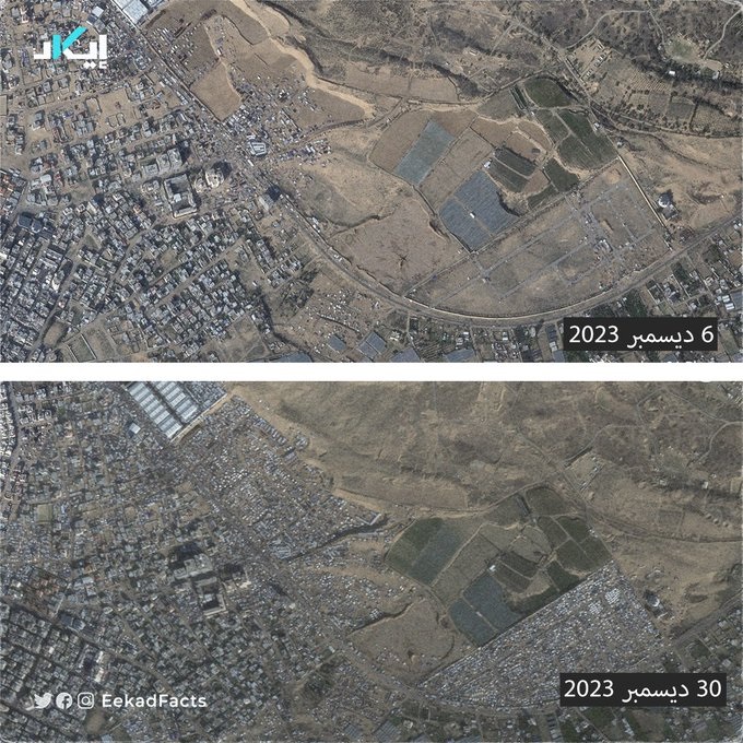
Watan-The scenes captured by satellites between December 6 and 30 last year reveal the overcrowding of Rafah city in the southern Gaza Strip. The images show the city filled with tents of displaced individuals who fled from the bombardment.
The area documented in these scenes is located near a United Nations facility and is approximately 2 kilometers away from the Egyptian border.
100,000 Palestinians Head Toward Rafah
The United Nations Office for the Coordination of Humanitarian Affairs (OCHA) stated that 100,000 Palestinians have been forced to head towards the Rafah area near the borders with Egypt in recent days due to the attacks launched by the Israeli occupation army on the central areas of the besieged Gaza Strip and the Khan Younis area in the south.
#جيوبوست | نشر الصحفي “Jake Godin” صور أقمار صناعية مُلتقطة بين 6 و30 ديسمبر، تُظهر امتلاء منطقة رفح بخيام النازحين الذين فروا من القصف.
✔️هذه المنطقة تقع بالقرب من منشأة للأمم المتحدة، وتبعد عن الحدود المصرية نحو 2 كم.
✔️ووفقًا لمكتب الأمم المتحدة لتنسيق الشؤون الإنسانية… pic.twitter.com/Fi3ycL1yMr
— EekadFacts | إيكاد (@EekadFacts) January 1, 2024
In a statement, OCHA mentioned that the intense Israeli attacks on Khan Younis (south) and Deir al-Balah (central) prompted 100,000 Palestinians to move towards the Rafah border area with Egypt.
According to data as of December 20th, there were 12,000 individuals per square kilometer in the Rafah area, making it the most densely populated area in Gaza.
The statement highlighted that the influx of new displaced individuals to the Rafah area has worsened the conditions in the already crowded region due to limited resources.
UNRWA (United Nations Relief and Works Agency for Palestine Refugees) previously mentioned that the number of displaced individuals in the city of Rafah exceeded 657,000, with a significant portion living without shelter.
The Israeli war on Gaza concluded on its 87th day, with the occupation army intensifying its airstrikes and bombardments across the territory. The Ministry of Health in Gaza announced an increase in the martyr toll to 21,978.


